Stormy Skies and Shifting Winds: Phoenix Braces for a Soggy Saturday
A Dramatic Shift in the Valley
The quiet, mild weather that has characterized much of January in Phoenix is coming to a close this Saturday, January 24, 2026. A powerful cold front is set to sweep through Central Arizona today, bringing a significant change in conditions that will likely disrupt outdoor plans across the Valley. Residents should prepare for a transition from overcast skies to active weather as the day progresses, marking a sharp departure from the recent above-average warmth.
Morning Cloud Cover and Rising Winds
The day began with thick cloud cover and temperatures hovering in the high 40s. Throughout the morning, humidity levels are expected to climb as the atmosphere becomes more saturated ahead of the approaching front. While the early hours may remain largely dry, the most notable change will be the wind. A north-northwesterly flow will begin to strengthen, with sustained winds increasing as the cold front nears the metropolitan area. Expect breezy conditions to develop before the noon hour, serving as the first sign of the incoming storm system.
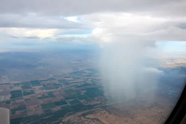
Afternoon Showers and Potential Thunderstorms
By early afternoon, the weather is expected to take a more active turn. Meteorologists are tracking a line of scattered to numerous showers moving into South-Central Arizona. There is an approximately 40% to 50% chance of rain in the Phoenix basin, with the highest probabilities relegated to the foothills and high terrain to the east. Residents should also keep an ear out for the occasional rumble of thunder; while instability profiles are modest, there is enough energy to spark isolated thunderstorms during the peak heating hours of the day.
- High Temperature: Mid-60s (peaking around 65°F).
- Precipitation: Scattered showers with a risk of isolated thunderstorms and rainfall amounts up to 0.37 inches.
- Wind Alerts: Gusts of 20 to 30 mph, with potential peak gusts reaching 40 mph due to the frontal passage.
Evening Outlook and Cooling Trend
As the sun sets, the cold front will continue its progression through the region. Showers may linger into the late evening hours before tapering off overnight. The most pressing concern during the evening commute will be the gusty winds, which could impact high-profile vehicles on Valley freeways. Following the passage of the front, temperatures will begin to drop sharply. Overnight lows are forecasted to dip into the mid-to-low 40s, marking a return to the chilly desert nights typical of the season. By tomorrow morning, the skies are expected to clear, but the cooler air mass will remain firmly in place for the remainder of the weekend.
Safety Reminders
Due to the forecasted wind gusts of up to 40 mph, residents are encouraged to secure loose patio furniture and outdoor decorations. If you encounter heavy rain or reduced visibility while driving, remember to slow down and allow for extra distance between vehicles. With temperatures dipping below normal this weekend, tonight is the perfect time to break out the heavier winter gear as we settle into a colder pattern for the final week of January.