Hold Onto Your Hats: Dust and Gusty Winds Set to Sweep Through the Valley
A Shifting Pattern for the Valley of the Sun
Residents in Phoenix should prepare for a significant shift in weather patterns today, Monday, February 16, 2026. While the morning may start with relatively calm conditions, a potent weather system is moving into the region, bringing with it a transition from mild spring-like temperatures to gusty winds and a chance of evening showers. The National Weather Service has indicated that this front will mark the beginning of a cooling trend that will persist through the middle of the week.
Morning: Increasing Clouds and Mild Conditions
The day began with filtered sunshine and a light breeze, but cloud cover is expected to increase steadily throughout the morning hours. Early temperatures were recorded in the mid-50s, climbing toward the low 70s by noon. For those planning outdoor activities early in the day, conditions remain favorable, though the approach of the cold front will be signaled by a steady drop in barometric pressure and a noticeable shift in wind direction. By the late morning, the atmosphere will begin to feel significantly more unsettled.
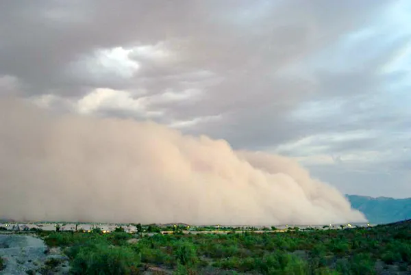
Afternoon: Wind Advisory in Effect
The primary concern for today is the arrival of high-velocity winds. The National Weather Service has issued a Wind Advisory for the Phoenix metropolitan area and surrounding desert regions, effective from 2:00 PM today through early Tuesday morning. Forecasters expect southwest winds to sustained speeds of 20 to 30 mph, with powerful gusts reaching up to 45 mph. These conditions are likely to create hazardous travel for high-profile vehicles and may result in localized blowing dust, which could briefly reduce visibility to under a mile in open desert areas. The daytime high is expected to peak between 73°F and 76°F before the cold front begins to drop temperatures later in the day.
Evening: Rain Potential and Cooling Down
As the sun sets, the focus will shift from wind to precipitation. While the desert floor often remains dry, this system carries enough moisture to bring scattered showers to the Valley. Meteorologists predict rainfall totals for the lower desert areas could reach up to 0.10 inches by tonight. The evening low will dip to around 56°F as the colder air mass settles in. Residents are advised to secure loose outdoor items like patio furniture and umbrellas, as the strongest gusts are expected to coincide with the passage of the front tonight.
Today’s Weather Summary
- High Temperature: 73°F to 76°F
- Low Temperature: 56°F
- Wind Hazards: Wind Advisory starting at 2:00 PM with gusts up to 45 mph.
- Precipitation: 40% chance of light rain showers (up to 0.10 inches).
- Visibility Warning: Potential for blowing dust during peak afternoon wind periods.