Hold Onto Your Hats: 35 MPH Gusts and Unseasonable Warmth Sweep Through Phoenix
High Pressure Brings Record-Near Warmth
Phoenix residents should prepare for a significant shift in conditions today, Wednesday, February 4, 2026. A powerful high-pressure system settled over the Desert Southwest is driving temperatures well above the seasonal norm. Current data from the National Weather Service indicates that the Valley will experience afternoon highs between 8 and 14 degrees above typical February averages. While the early morning started at a crisp 51°F, the mercury is expected to climb rapidly throughout the day, reaching a peak near 72°F to 75°F.
Morning Outlook: Clear Skies and Rising Breezes
The morning hours will remain largely sunny and clear, offering a deceptive calm. However, breezy conditions are expected to develop across central Arizona as early as 9:00 AM. As the atmosphere warms, the pressure gradient will tighten, leading to sustained winds that will steadily increase in intensity. Residents planning early outdoor activities should take advantage of the calmer window before noon, as visibility and comfort levels are expected to decline as the wind picks up.
Afternoon and Evening: Peak Wind Gusts and Travel Hazards
The core of today’s weather story is the wind. Stronger gusts are predicted to impact the Phoenix metro area starting in the mid-afternoon and persisting through the late evening hours. Forecast models suggest sustained winds of 15 to 25 mph, with localized gusts reaching up to 35 mph. These conditions are particularly prevalent along major travel corridors, including Interstate 10, US-60, Loop 101, and State Route 202. Motorists, especially those operating high-profile vehicles like trucks and SUVs, should exercise extreme caution when traveling east or west of the metro area where open desert terrain offers little protection from crosswinds.
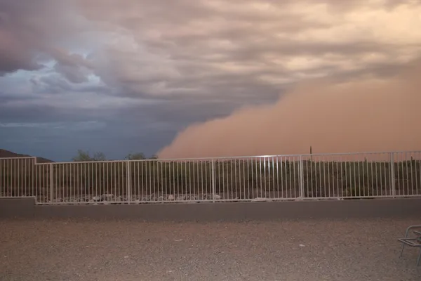
Blowing Dust and Safety Precautions
With the ground remaining dry following a warm January, the National Weather Service has warned of the potential for localized blowing dust or sand. This could briefly reduce visibility to dangerous levels in dust-prone locations such as Buckeye and Apache Junction. To ensure safety and protect property, phoenix.news recommends the following actions:
- Secure loose outdoor items, including patio furniture, umbrellas, and trash bins, to prevent them from becoming airborne projectiles.
- Ensure temporary structures or construction materials are properly anchored.
- Be prepared for sudden drops in visibility while driving and avoid using high beams in dusty conditions.
Winds are expected to remain active overnight, with peak intensity continuing through Thursday before gradually diminishing by Friday morning.